 |
 |
| Photo of the Canyon Lake Dam in 1964
before reservoir impoundment begun. Photo Courtesy of US Army Corps
of Engineers |
|
| |
 |
|
Canyon Lake running over the spillway
in July 2002. Photo Courtesy of the Comal County Engineer's Office |
| |
|
| |
 |
| |
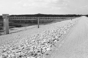
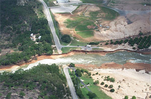
The spillway waters destroyed part
of the South Access Road in July 2002. Photo Courtesy of the Comal
County Engineer's Office |
| |
|
| |
 |
| |
The spillway waters destroyed part
of the South Access Road in July 2002. Photo Courtesy of the Comal
County Engineer's Office |
| |
|
| |
 |
| |
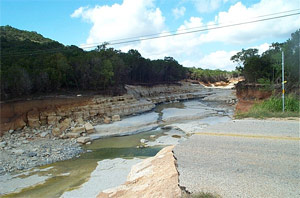
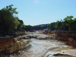
The spillway waters
carved a scenic new gorge out of the limestone bedrock in July 2002. |
The site initially identified for Canyon Dam was about five miles upstream
from New Braunfels. After the 308 report, additional hydrologic studies
were done, and the underlying limestone rock was found to be so honey-combed
and porous that engineers had serious concerns about major leakage that
could occur. Large losses might make power generation infeasible, so Chief
Engineer E. A. Markham recommended additional study and did not recommend
the project at that time. The Board of Engineers for Rivers and Harbors
rejected the 308 Report recommendations for constructing Canyon Dam.
There were major floods in 1936 and 1938, and a group of civic, business,
and agricultural leaders formed the Guadalupe-Blanco Basin Improvement
Association and started to demand the federal government take action on
flood control. The group asked Congress to authorize the Corps of Engineers
to reevaluate the Canyon Lake project, and the Corps issued a favorable
report that led to Congressional authorization for construction of the
Dam in the Rivers and Harbors Act of 1945. The Corps was instructed to
prepare a pre-construction report, the Definitive Project Report, which
it completed in 1951. The Report recommended moving the dam site about
16 miles upstream, and it also recommended postponing power generation
because leakage losses were still projected to account for as much as
25% of total storage. The engineers thought it would be better to wait
and see how much water would actually be available for power generation
so they could size the generating capacity accordingly. Final approval
for construction was given in the Flood Control Act of 1954.
 |
|
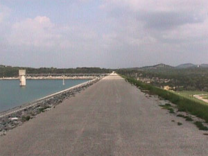
Photo of the
Canyon Lake Dam |
In a letter to the Corps of Engineers in July 1955, the Texas Board of Water
Engineers reaffirmed the Guadalupe-Blanco River Authority's role as the
state agency with whom the Corps of Engineers should negotiate and coordinate
the details of construction and operation of Canyon Reservoir. In September
1957 the two agencies formalized their relationship as partners in the project
with a contract that allocated costs and operations & maintenance responsibilities.
After some funding delays were overcome, construction of Canyon Dam on
the Guadalupe River Mile 303 began in 1958. Water impoundment began in
1964 and essentially completed by June 1964; the conservation pool level
was reached in 1968. Canyon Dam was finally dedicated on April 20 1966.
The total cost was $20.2 million.
It was constructed to serve two purposes - flood control and water conservation.
Flood protection is provided to 157,250 acres of land downstream from the
dam. The high canyons of the upper Guadalupe have a channel capacity of
40,000-50,000 cubic feet per second. The channel on the lower Guadalupe
River has a capacity of only 13,000-30,000 cubic feet per second; therefore,
the lower Guadalupe River Basin had been especially subject to serious flooding.
The construction of Canyon Dam on the edge of the Balcones Escarpment has
been very effective in protecting the lower Guadalupe River Basin.
 |
|
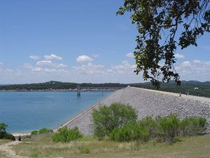
Photo of the Canyon
Lake Dam. Photo Courtesy of US Army Corps of Engineers |
At conservation pool level the lake has a capacity of 382,000 acre-feet.
It has a surface area of 8,230 acres and 80 miles of shoreline. At flood
control pool level of 943-ft msl, the lake has an additional capacity of
346,000 acre-feet making total storage 728,400 acre-feet.
The Guadalupe-Blanco River Authority (GBRA) is the local agency with
rights to the water in the conservation pool of the lake. The Authority
contributed to the construction costs and currently pays the U.S. Government
annually for the portion of operation and maintenance costs attributed
to the conservation pool water. The water is used to operate several small
hydroelectric plants downstream from New Braunfels. It is also used by
the GBRA for municipal water supply, irrigation, and industrial uses.
GBRA began construction of a hydroelectric facility at Canyon Dam in August
1987; it was first put into service in February 1989.
To date, it has been estimated that millions of dollars in flood damage
has been averted from several major flood events in the area. In the ensuing
decades, with Canyon Dam in place, recreation and tourism flourished in
areas downstream that had previously been subjected to severe floods.
Homes, summer cottages, campgrounds, water outfitters, and tubing operations
all became commonplace and part of the south Texas culture.
The first major flood event occurred in August 1978 when the lake elevation
reached 930.6-ft msl. Within two days' time, 40 inches of rain fell on
the upper Guadalupe River. The river flowed into the lake at 115,000 cubic
feet per second causing the lake to rise 21.6 feet above the conservation
pool level of 909.0 feet above mean sea level. It was estimated that 24
million dollars of downstream damage was averted due to the flood protection
of Canyon Dam.
The flood in July 1987 reached a maximum lake level of 942.67-ft msl. In 1991-1992 floods, maximum elevation reached 937.77-ft msl.
Another flood event occurred in late June to early August 1997 when the
maximum elevation was 937.6-ft msl. Canyon Dam controls floods originating
on the 1,432 square miles of drainage above the dam.
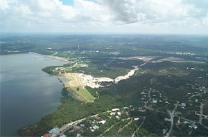
In July of 2002, a stubborn low-pressure system parked itself over the
region and much of south Texas received almost a year's worth of rainfall
in less than a week. Canyon Reservoir filled to capacity and water rushed
over the spillway for the first time ever. The southern access road to
the Dam was washed out, and more than 800 homes were destroyed or damaged.
With the reservoir at record levels, thousands of oak trees dotting the
shoreline began to suffer from a lack of oxygen and most were not expected
to survive. Discharges from the Dam had to be halted temporarily because
of rocks and debris that accumulated around the outlet structure. Residents
feared that when releases were initiated again, about 40 homes below the
dam would be flooded because rocks and debris that washed down the spillway
channel created a "plug" obstructing the Guadalupe's flow about
a mile below the Dam. The raging spillway waters created a scenic new
gorge, which the Guadalupe-Blanco River Authority leased from the Corps
of Engineers in October of 2005 to operate the site as a tourist attraction.
Click here for more information on the Canyon Lake
Gorge
The Dam has not been able to provide complete protection from floods.
In 1972, and again in 1998, intense rains below the Dam site resulted
in devastating floods in New Braunfels and areas downstream.
LAKE LEVELS:
909.0 ft msl - conservation pool
943.0 ft msl - spillway crest
948.0 ft msl - spillway crest, plus 5 feet spillway flow-high elevation
of flowage easement lands
899.7 ft msl - all time lowest lake pool after impoundment on December
13, 1984
950.32 ft msl - all time highest lake pool after impoundment on July 6,
2002.
|