Canyon Lake Parks

Canyon Beach Park
N 29°54.339’
W 098°13.526’

Phone: (830) 964-3341

INFORMATION:

Hours: 8am -7:20pm Daily

Season: March 1 to October 31

DAY USE ONLY FOR PAID GUESTS. WE DO NOT PROVIDE ANY CAMPING OR RV SITES.

Pets are allowed in park as long as they are leashed at all times.


FEES:

$5.00 per vehicle with a Comal County registration sticker and $20 per non-Comal County registration sticker.


DIRECTIONS:

Canyon Beach Park is located on the North shore of Canyon Lake near Hancock.

From IH 35: Take Exit 191 north of New Braunfels, Texas. FM 306 is exit 191. Drive West on FM 306 for about 20 Miles. You will turn left at the flashing yellow signal light on to Canyon Park Road.

From US Hwy 281: Turn East on FM 306. Travel east 12 miles. You will turn right at the flashing yellow signal light on to Canyon Park Road.

Canyon Beach Park gate house is on the left as you cross the causeway portion of the road. The first gate house is where you check in and pay for acces to the beach.


Canyon Park
N 29°53.872’
W 098°14.005’

Phone: (830) 964-3341


Click Here For More Canyon Park Information


INFORMATION:

Hours: 8am -7:20pm Daily

Season: March 1 to October 31

DAY USE ONLY FOR PAID GUESTS. WE DO NOT PROVIDE ANY CAMPING OR RV SITES.

Canyon Park is a 485- acre park located on the north shore of Canyon Lake. This lakefront park is currently open from March through October as a day-use only facility. Canyon Park has picnic sites, one boat ramp, a pea gravel and sand beach, and restrooms throughout the park. The park encompasses Canyon Swim Beach #1, Swim Beach #2, and the Madrone Trail.

Pets are allowed in park as long as they are leashed at all times.


FEES:

$5.00 per vehicle with a Comal County registration sticker and $20 per non-Comal County registration sticker.


DIRECTIONS:

Canyon Park is located on the North shore of Canyon Lake near Hancock.

From IH 35: Take Exit 191 north of New Braunfels, Texas. FM 306 is exit 191. Drive West on FM 306 for about 20 Miles. You will turn left at the flashing yellow signal light on to Canyon Park Road.

From US Hwy 281: Turn East on FM 306. Travel east 12 miles. You will turn right at the flashing yellow signal light on to Canyon Park Road.

Canyon Park gate house is at the very end of the road past the marina. Check in at the gate house please.

Comal Park

Location: 1178 Comal Park Rd, Canyon Lake, TX 78133 N 29°51.760’
W 098°15.143’

Phone: (830) 964-3341

DAY USE ONLY FOR PAID GUESTS. WE DO NOT PROVIDE ANY CAMPING OR RV SITES.


Click Here For More Comal Park Information


INFORMATION:

Hours: 8am -7:20pm Daily

Season: March 1 to October 31

Comal Park is a 116- acre park located on the South shore of Canyon Lake near Startzville. This lakefront park is currently open from March through October as a first- come, first-serve day-use only facility. No reservation is required to enter the park.

Comal Park has picnic sites, two boat ramps, a pea gravel and sand swim beach, a playground, and restrooms throughout the park. The park has a variety of recreational activities including a sand volleyball court, soccer goals, disc golf, and a 1.2 mile walking trail.

Pets are allowed in park as long as they are leashed at all times.


FEES:

$5.00 per vehicle with a Comal County registration sticker and $20 per non-Comal County registration sticker.


DIRECTIONS:

Comal Park is located on the South shore of Canyon Lake near Startzville.

From IH 35: Take FM 306 exit 191 just North of New Braunfels. Travel West on FM 306 for 14 miles to FM 2673 and turn left. Continue West on FM 2673 for 8 miles to the Dairy Queen in Startzville. turn right on Canyon Bend Street. Turn right at the Dairy Queen on Canyon Bend Street. Follow the Boat Ramp 5 signs to the park for an additional two miles.

From US Hwy 281: Take Hwy 46 East past Smithson Valley High School and turn left on FM 3159. Continue on FM 3159 for 6.7 miles, then turn left at the traffic light on FM 2673 in Startzville. Continue on FM 2673 for one mile to the Dairy Queen. Turn right at the Dairy Queen on Canyon Bend Street. Follow the Boat Ramp 5 signs to the park for an additional two miles.


Cranes Mill Park
N 29°53.340’
W 098°17.561’


Click Here For More Cranes Mill Park Information


LOCATION:

Cranes Mill Park is located on the Southwest shore of Canyon Lake off FM 2673, just past the town of Startzville.


DIRECTIONS:

From IH 35 take Canyon Lake exit west on FM 306; approximately 14 miles. Turn left on FM 2673 just after Guadalupe River crossing. Cranes Mill Park is located at the westernmost end of FM 2673 and South Cranes Mill Road.


Fort Sam Houston Recreation Area & Randolph Recreation Park
ARE NOW COMBINED AND CALLED
Joint Base San Antonio Recreation Area


Phone: (830) 964-3576


Click Here For More Joint Base San Antonio Recreation Area Information


DIRECTIONS:


The facility is located 48 miles north of San Antonio.


Take Interstate 35 through New Braunfels to the Canyon Lake exit (Exit 191).


Turn left on Farm Road 306.


Drive approximately 16 miles to Canyon City.


Continue another 1½ miles past the blinking light in Canyon City to Jacobs Creek Park Road.


Welcome to Joint Base San Antonio Recreation Park at Canyon Lake; turn right to check in.


Guadalupe Park
N 29°52.168’
W 098°11.658’


Phone: (830) 964-3341


INFORMATION:


Hours: Sunrise -Sunset Daily
Season: Open All Year


Facilities: Day Use - OPEN TO ALL FOR HIKING AND FISHING!


Useage of Guadalupe Park is free of charge. You can Hike or Fish in this park. NO camping allowed.


Guadalupe Park is located below Canyon Dam along the first mile of the Guadalupe River. It features an ADA-accessible parking lot and trailway with fishing pier on the north side. A foot trail is available along the river on the south side of the park. The river can be accessed from the trails for fishing. Please have a state fishing license.


The Guadalupe-Blanco River Authority (GBRA) manages a hydropower plant along the north side of the river near the fishing pier. This stretch of the Guadalupe river is very popular as the State's premier trout fishing stream. The Guadalupe River is the Southernmost sustainable trout fishery in the nation. No restroom, camping or picnic facilities are available in the park. Sometimes a portable toilet is provided. The nearest restroom facility is located at nearby Overlook Park near the southern end of Canyon Dam. Overlook Park closes at sunset daily.


DIRECTIONS:


Guadalupe Park is located below Canyon Dam along the first mile of the Guadalupe River.


From IH 35: Take FM 306 exit 191 just North of New Braunfels. Travel West on FM 306 until you cross the Guadalupe River where the tubing occurs. About 2 miles after the river, you will come to a stop light. Turn left on to the road. This is South Access Road.

Just around the first bend is the park on your left. There are no signs with the park name on them. Feel free to use any of the three parking areas. The ADA accessible parking is the first parking lot and is paved. The other two parking lots are dirt. They are situated on each side of the stilling basin where the water flows from the dam.


From US Hwy 281: Take Hwy 46 East past Smithson Valley High School and turn left on FM 3159. Continue on FM 3159 for 6.7 miles, then turn right at the traffic light on FM 2673 in Startzville. Follow FM 2673 until you come to the stop light in Sattler. Turn left at the light. Follow South Access Rd for about 1.5 miles. The tall green hill of the dam will be in front of you and the park will be on your right. The entrance to the park is on your right as you drive past the dam.


North Park
N 29°52.507’
W 098°12.074’


Click Here For North Park Information


DIRECTIONS:


North Park is located off FM 306 near the dam.


From IH 35: Take FM 306 exit 191 located just west of New Braunfels. Travel west on FM 306 for about 18.5 miles until you get to North Park Road. Turn onto North Park Road and follow it until you come to the park at the far end of the road.


From US Hwy 281: Take FM 306 east about 16.5 miles until you get to North Park Road. Turn onto North Park Road and follow it until you come to the park at the far end of the road.


Please check in at the gate house before entering the park.


Overlook Park
N 29°51.663’
W 098°11.891’


Phone: (830) 964-3341


DIRECTIONS:


From IH 35: Take FM 306 exit 191 just North of New Braunfels. Travel West on FM 306 until you cross the Guadalupe River where the tubing occurs. About 2 miles after the river, you will come to a stop light. This is South Access Road. Turn left on to the road. Follow the road around the base of the dam. The first road on your right will be C.O.E. Road. There are two large swing gates that are open during the day and a brown sign that says Canyon Lake. Turn right and proceed up the hill.


From US Hwy 281: Take Hwy 46 East past Smithson Valley High School and turn left on FM 3159. Continue on FM 3159 for 6.7 miles, then turn right at the traffic light on FM 2673 in Startzville. Follow FM 2673 until you come to the stop light in Sattler. Turn left at the light. Follow South Access Rd for about 1.5 miles. The tall green hill of the dam will be in front of you and the park will be on your left. Turn left between the stone gates. A large brown sign on the right say 'Canyon Lake'. Drive to the top of the hill and find a parking place to stay and enjoy your day.


Potter's Creek Park
N 29°54.411’
W 098°15.821’


Click Here For More Potter's Creek Park Information


DIRECTONS:


The Park is located on the northwest side of Canyon Lake off of Potter's Creek Road near the Hwy 484 (Fischer Road) junction.


From IH 35 take FM 306 (exit #191) located just north of New Braunfels, Texas. Travel west on FM 306 for 26 miles. Turn south on Potter's Creek Road and continue two miles to reach the park entrance.


From US 281 take FM 306 east 10 miles. Turn south on Potter's Creek Road and continue two miles to reach the park entrance.


Randolph Recreation Park & Fort Sam Houston Recreation Area
ARE NOW COMBINED AND CALLED
Joint Base San Antonio Recreation Area


Phone: (830) 964-3576


Click Here For More Joint Base San Antonio Recreation Area Information


DIRECTIONS:


The facility is located 48 miles north of San Antonio.


Take Interstate 35 through New Braunfels to the Canyon Lake exit (Exit 191).


Turn left on Farm Road 306.


Drive approximately 16 miles to Canyon City.


Continue another 1½ miles past the blinking light in Canyon City to Jacobs Creek Park Road.


Welcome to Joint Base San Antonio Recreation Park at Canyon Lake; turn right to check in.


Information Courtesy of US Army Corps of Engineers

Back


Canyon Lake Texas is a true hidden treasure of the Central Texas Hill Country. With breathtaking waterfront and lake views; this is the place where many are starting to call home. White tailed deer, foxes, roadrunners, and other wildlife are in abundance in the Texas Hill Country and especially at Canyon Lake. The Texas Hill Country is famous for its hilly terrain, live oak trees, limestone rocks, native animals, and clean fresh air.


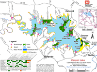
Canyon Lake, Texas has so much to offer: Boating/Sailing, Water Skiing, Kayaking, Fishing, Scuba Diving, Helicopter Tours, Parasailing, Hiking, Dining, Shopping, and much more. Canyon Lake is located just forty miles north of San Antonio and twenty-five miles west of New Braunfels and San Marcos.


Canyon Lake has eight Corps of Engineer Public Parks, 23 boat ramps, two marinas, campgrounds, golf course, country club, and yacht club. The lake has a surface area of 8,230 acres and 80 miles of shoreline. Canyon Lake releases water down stream into the famous Guadalupe River.

Canyon Lake TX Home Page |  Attractions |  Business Directory |  Helpful Information |  Pictures & Videos |  Maps |  Advertise |  Contact


Canyon Lake Texas Information Guide
Lodging, Bed & Breakfasts, Vacations, Travel, Restaurants, Shopping, Real Estate Property, Waterfront,
Waterview, Realtor Information, Boating, Sailing, Water Skiing, Kayaking, Fishing, Scuba Diving, Parasailing