|
Texas Set to Open New Canyon to Public
The Associated Press Oct 5, 2007
By MICHELLE ROBERTS
CANYON LAKE, Texas (AP) — The formation of canyons, done with the
flow of water over rock and time, is generally a practice in patience.
But not here.
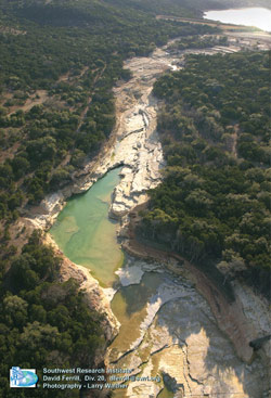
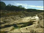
A torrent of water from a bloated Canyon Lake sliced open the earth,
exposing rock formations, fossils and even dinosaur footprints in just
three days. To protect Canyon Lake Gorge from vandals, it's been open
only to researchers since the 2002 flood, but on Saturday, it opens to
its first public tour.
"It exposed these rocks so quickly and it dug so deeply, there wasn't
a blade of grass or a layer of algae," said Bill Ward, a retired
geology professor from the University of New Orleans who started cataloguing
the gorge almost immediately after the flood.
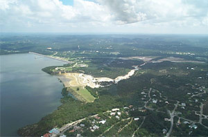
The gorge, which emerged where a nondescript valley covered in mesquite
and oak trees once was, sits behind a spillway built as a safety valve
for Canyon Lake, a popular recreation spot in the Texas Hill Country between
San Antonio and Austin.
The reservoir was built in the 1960s to prevent flash flooding along
the Guadalupe River and to assure the water supply for central Texas.
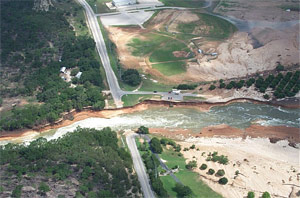
The spillway, which protects the dam by giving the water an outlet if
it gets too high, had never been overrun until July 4, 2002, when 70,000-cubic
feet of water flowed through the 1,000-foot gap for three days. It gushed
downhill toward the Guadalupe River and scraped the vegetation and topsoil
off, leaving only limestone walls.
"Underneath us, it looks solid, but obviously it's not," said
Tommie Streeter Rhoad of the the Guadalupe Blanco River Authority, as
she looked out over a cream-colored limestone crevasse that plunges 80
feet at its deepest spot.
The sudden exposure of such canyons is rare but not unprecedented. Flooding
in Iowa in 1993 similarly opened a limestone gorge behind a spillway at
Corvalville Lake north of Iowa City, but Devonian Fossil Gorge is narrower
and shallower than Canyon Lake Gorge.
Neither compares to the most famous of canyons, the Grand Canyon. It
took water around 5 million to 6 million years to carve the crevasse that
plunges 6,000 feet at its deepest point and stretches 15 miles at its
widest.
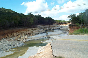
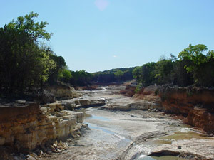
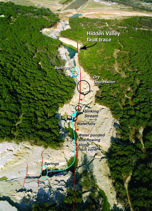
The more modest Canyon Lake Gorge, however, still displays a fault line
and rock formations carved by water that seeped down and bubbled up for
millions of years before the flooding.
Some of the canyon's rocks are punched with holes like Swiss cheese and
the fossils of worms and other ancient critters are everywhere. The rocks,
typical of the limestone buried throughout central Texas, date back "111
million years, plus or minus a few hundred thousand years," Ward
said.
Six three-toed dinosaur footprints offer evidence of a biped carnivore
strolling along the water. The footprints were temporarily covered with
sand to protect them as workers reinforced the spillway, but they'll be
uncovered again eventually, Rhoad said. Other footprints belonging to
quadraped dinosaurs are exposed, too, all moving east to west along what
would have been the waterfront, Ward said.
Year-round pools of blue-green water collect along the gorge's bottom.
Some still have fish that came in with the 2002 flood waters that lasted
roughly six weeks as rain hit the state with an estimated $1 billion in
property damage.
The Guadalupe Blanco River Authority, which has a lease from the Army
Corps of Engineers to manage the 64-acre Canyon Lake Gorge site, will
begin offering limited public tours of the canyon Saturday, continuing
year-round on the first Saturday of the month.
Early demand for the 3-hour tours is so high they are booked for at least
six months, and Rhoad said the GBRA hopes to find and train more docents
so tour dates can be added. The tours include a hike of the 1 1/2-mile-long
crevice with discussions on the history and geology of the canyon.
Visitors will not be allowed to hike the canyon on their own, because
the brittle limestone is still breaking away from the canyon walls.
Construction on a rim trail to overlook the canyon begins this winter,
and Rhoad said officials hope to eventually build lookout points and an
educational center.
 Canyon
Lake Gorge Tours: www.canyongorge.org Canyon
Lake Gorge Tours: www.canyongorge.org
|